- ImageCLEF 2024
- LifeCLEF 2024
- ImageCLEF 2023
- LifeCLEF 2023
- ImageCLEF 2022
- LifeCLEF2022
- ImageCLEF 2021
- LifeCLEF 2021
- ImageCLEF 2020
- LifeCLEF 2020
- ImageCLEF 2019
- LifeCLEF 2019
- ImageCLEF 2018
- LifeCLEF 2018
- ImageCLEF 2017
- LifeCLEF2017
- ImageCLEF 2016
- LifeCLEF 2016
- ImageCLEF 2015
- LifeCLEF 2015
- ImageCLEF 2014
- LifeCLEF 2014
- ImageCLEF 2013
- ImageCLEF 2012
- ImageCLEF 2011
- ImageCLEF 2010
- ImageCLEF 2009
- ImageCLEF 2008
- ImageCLEF 2007
- ImageCLEF 2006
- ImageCLEF 2005
- ImageCLEF 2004
- ImageCLEF 2003
- Publications
- Old resources
You are here
GeoLifeCLEF2022
Motivation
Automatic prediction of the list of species most likely to be observed at a given location is useful for many scenarios related to biodiversity management and conservation.
First, it could improve species identification tools (whether automatic, semi-automatic or based on traditional field guides) by reducing the list of candidate species observable at a given site.
More generally, this could facilitate biodiversity inventories through the development of location-based recommendation services (e.g. on mobile phones), encourage the involvement of citizen scientist observers, and accelerate the annotation and validation of species observations to produce large, high-quality data sets.
Last but not least, this could be used for educational purposes through biodiversity discovery applications with features such as contextualized educational pathways.
Data collection
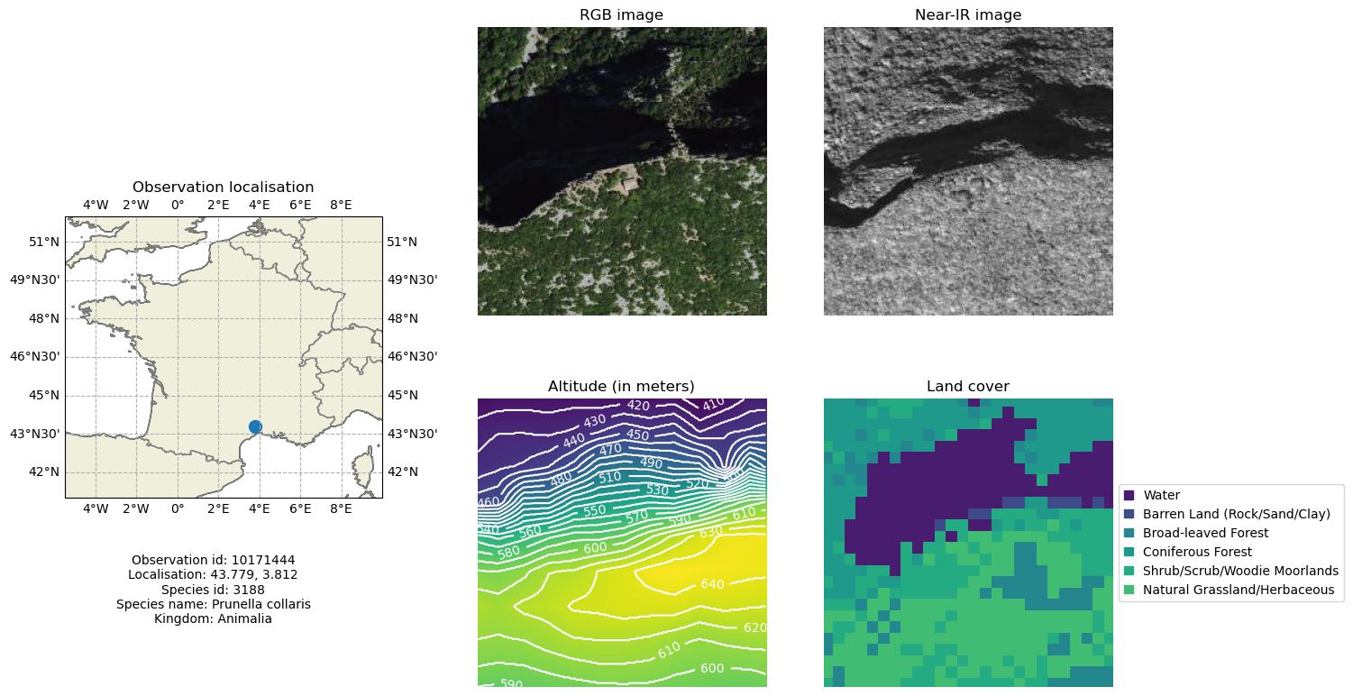
The challenge relies on a collection of millions of observations of plants and animals in the US and France (from citizen science projects iNaturalist and Pl@ntNet).
In addition to geo-coordinates and species name, each observation is matched with a set of geographic images characterizing the local landscape and environment around the observation.
In more detail, this includes: (i) high resolution (about 1 meter per pixel) remotely-sensed imagery (from NAIP for the US and from IGN for France), (ii) bio-climatic rasters from WorldClim (1 km resolution) and (iii), land cover rasters (from NLCD for the US - 30m resolution - and from Cesbio for France - 10m resolution).

Task description
The detailed description of the task is provided on the Kaggle page of the challenge.
In a nutshell, the observation dataset is split in a training set with known species name labels and a test set used for the evaluation.
For each observation in the test set (paired with the corresponding aerial image and environmental co-variates), the goal of the task will is to return a candidate set of species.
The evaluation metric will be the top-30 error rate.
How to participate ?
1. Subscribe to CLEF (GeoLifeCLEF task) by filling this form
2. Go to the Kaggle's GeoLifeCLEF 2022 challenge page
Credit
This project has received funding from the French National Research Agency under the Investments for the Future Program, referred as ANR-16-CONV-0004 and from the European Union’s Horizon 2020 research and innovation program under grant agreement No 863463 (Cos4Cloud project).
| Attachment | Size |
|---|---|
| 148.19 KB | |
| 407.6 KB |